


- Yunlin Bamboo Industry Forum Launched, Outlining a Sustainable Blueprint for the Bamboo Industry
- Yunlin County presents results of agricultural climate adaptation plan in response to climate change
- PX Mart celebrates Winter Solstice with Yunlin Goods Month: Magistrate Chang Li-shan and top chef showcase nutritious local ingredients
- Yunlin County Magistrate Chang shares vision for agricultural sustainability and industrial transformation at the 2025 Taiwan Future International Summit
- Yunlin County Government relocates Oryzias chenglongensis to safeguard the endemic species
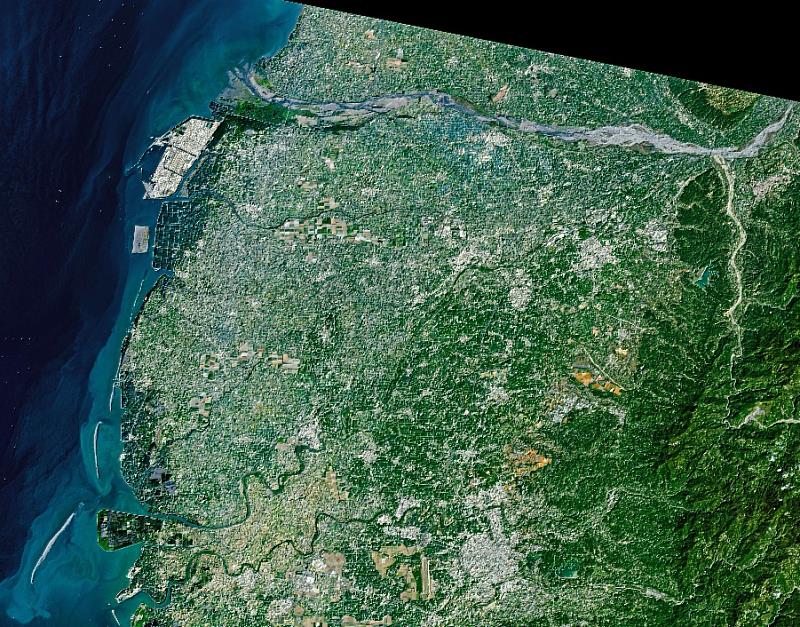
Yunlin from space: NASA satellite images reveal a stunning mosaic of farmland.
(中央社訊息服務20260505 14:20:19)Yunlin County, a major agricultural region in Taiwan, has recently stepped onto the international stage thanks to satellite imagery from NASA. An image taken by the Landsat 9 satellite on March 18, 2026, shows the county's farmland interwoven into a mosaic-like landscape, showcasing Yunlin's diverse and efficient agricultural production.
Situated between the alluvial plains of the Zhuoshui and Beigang Rivers, Yunlin County boasts ideal farming conditions such as flat terrain, fertile soil, and reliable irrigation, cementing its status as one of Taiwan's primary agricultural regions for decades. The county has a rich variety of crops, including rice, sweet potatoes, peanuts, corn, sugarcane, garlic, scallions, and various fruits and vegetables. It is also the largest pig farming area in Taiwan, and its agricultural output and supply capacity remains pivotal to the nation’s food security.
In the special article, NASA described how the image reveals a unique and densely utilized agricultural landscape, characterized by small, rectangular plots separated by a sophisticated network of roads and irrigation. This pattern reflects the relatively small scale of Taiwan’s farmland while demonstrating the county's long-term success in precision management and efficient land use.
In addition, some of the larger farmlands shown are remnants of the sugar industry's development during the Japanese colonial period. The consolidated, large-scale sugarcane plantations of that era are still visible in the Baozhong area today. While sugarcane cultivation has decreased in recent years, the associated heritage and agricultural landscape remain important historical assets for Yunlin.
In Xiluo Township, the image shows farmland with a distinctive blue-green hue, stemming from the widespread use of greenhouse cultivation. These facilities mitigate the impact of climate-driven heavy rainfall and pests while enhancing the quality and stability of high-value crops, a testament to the county’s achievements in agricultural technology and modernization.
Yunlin County Magistrate Chang Li-shan (張麗善) stated that the county is actively promoting agricultural facilities and smart agriculture, strengthening infrastructure, and balancing industrial development with environmental sustainability. These efforts ensure Yunlin remains competitive despite global climate shifts and market fluctuations. She hopes that international media exposure will showcase the diverse value of Yunlin’s agriculture and the beauty of its landscape.
Agriculture Department Director Wei Sheng-de (魏勝德) emphasized that agriculture is more than just an industry; it is a vital part of culture and daily life. The county remains committed to innovation and sustainability, fostering an agricultural environment that is both productive and resilient to ensure the sector continues to thrive.
Original URL: https://science.nasa.gov/earth/human-dimensions/agriculture/an-agricultural-mosaic-in-taiwan/#:~:text=Farms%20raising%20an%20array%20of%20crops%20form%20an,Imager%29%20on%20Landsat%209%20on%20March%2018%2C%20